Map of Tennessee Reduced from Large Map by J.B. Killebrew
- Creator: J.B. Killebrew (1831-1906)
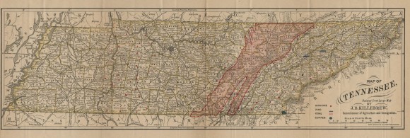
- Title: Map of Tennessee Reduced from Large Map by J.B. Killebrew
- Date: ca. 1875
- Description: Black and white map of Tennessee, with red shading for counties in a wide swath north to south encompassing the Cumberland Plateau and various red dots in three distinct portions of the state.
- Historical Note: This map was created by Tennessee's first Commissioner of Agriculture, Joseph Buckner Killebrew, in order to highlight the locations of iron ore, coal, zinc, and copper deposits in Tennessee. The shaded red area represents potential coal fields, while red dots show iron ore in the western highland rim area of Middle Tennessee, in areas within and on the eastern edge of the Cumberland Plateau, and in upper East Tennessee. As Commissioner of Agriculture, Killebrew encouraged the development of natural resources like timber, coal, and iron during a period of great expansion when investors, some of them former Union soldiers, moved into Tennessee after the Civil War. He was appointed to the post in 1871 and served until 1880.
- Contributing Institution: Vanderbilt University Libraries
- Rights: Images reproduced on this website are intended for individual, educational use only. For research inquiries about specific objects or requests for high resolution images, contact Vanderbilt University Libraries.
- Digital Publisher: Digital Initiatives, James E. Walker Library, Middle Tennessee State University
- URL: http://cdm15838.contentdm.oclc.org/cdm/landingpage/collection/shades
